ikfoundation.org
Promoting Natural & Cultural History

- WELCOME
- RESEARCH & ENTERPRISE
- THE IK WORKSHOP SOCIETY
- FIELD STATION
- BOOKS & ART0


- CONTACT
iFellows Sign In
Find out more about becoming an iFellow...My Basket
Items: 0Total: €0.00


 FIELD STATION OVERVIEW
SCIENTIFIC RESEARCH PROJECTS
| PANORAMIC PHOTOGRAPHIC HD MONITORING OF THE LOCAL BIOSPHERE

PANORAMIC PHOTOGRAPHIC HD MONITORING OF THE LOCAL BIOSPHERE
THE IK FOUNDATION
THE IK FOUNDATION
- PROJECT TITLE: PANORAMIC PHOTOGRAPHIC HD MONITORING OF THE LOCAL BIOSPHERE
- ESTIMATED START-UP TIME: Autumn 2018
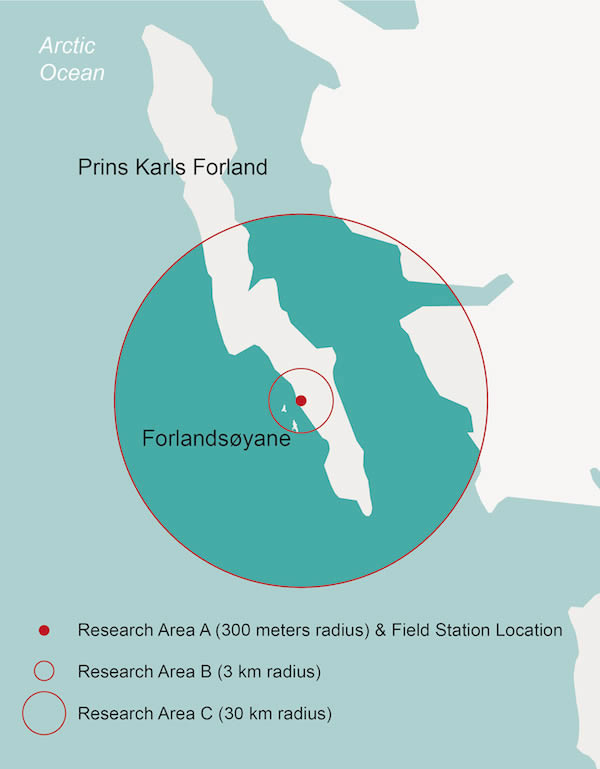
- GEOGRAPHICAL RESEARCH / MONITORING AREA: Area A up to C
ABSTRACT
 The project has two goals in the research areas (Area A up to B = approx. 3 km radius) and the third area (Area C = approx. 30 km radius) from Field Station | Naturae Observatio, using panoramic digital HD photographs: (I) Continuous photographing of selected areas of the landscape for a year cycle, to closely follow the fauna, flora and the elements (the local biosphere). (II) To provide documentary research support for other ongoing research projects related to the Field Station: in the disciplines of biology, meteorology and astronomy.
INTRODUCTION
Even in present-day, Prins Karls Forland and Forlandsøyane are only visited by a limited number of individuals – interested in the areas great variety of bird life, Arctic flora, rich maritime life, glaciers or geological formations. The uninhabited Prins Karls Forland has a diverse landscape, from alpine peaks over 1000 meters high, hilly topography to flat land and is part of the north Arctic tundra zone. Since 1973 the entire island and surrounding sea area is protected as – Forlandet National Park – due to its unique and multi-facetted natural environments. The bird sanctuary and wetland on the island(s) have also been recognised of international importance under the Ramsar Convention.The flat landscape by the west coast of Forlandsletta is ideal for a firmly installed photographic documentation based on preset daily observations of selected areas across the landscape. The panoramic view – along with high resolution digital images and with light-sensitive photography in colour during the polar night – will add knowledge to other ongoing research projects as well as valuable and unique understanding of the area's local biospheric cycle.
Responsible for the project is The IK Foundation, which together with other participating institutions and authorities will use the collected material within each project as a documentary support for the studies of the area. In addition, material will be made available as a permanent record – and filed in long term – under an open Creative Commons license for other research projects and organisations with an interest in the area.
AIM OF STUDY PROPOSED
The project scheme proposed includes advanced and long-term panoramic photographic documentation on selected parts of the landscape, and documenting of an annual cycle of the lithosphere, hydrosphere and atmosphere (the local biosphere) through a firmly installed special camera equipment. To thereby increase knowledge about the area's local biosphere, whilst the documentation is an important complement to other ongoing multidisciplinary research projects linked to Field Station | Naturae Observatio. The project is supposed to last for three year cycles (starting in the Autumn 2018), each year documenting about one third of a total 360 degree angle of the landscape.
APPROACH OF STUDY
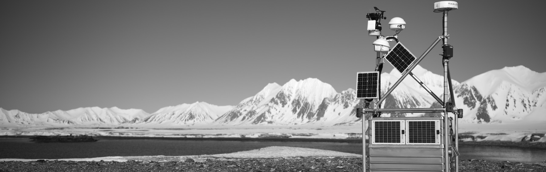
Panoramic photography is a technique that has a very long tradition in both the arts and history of photography. However, it can be said that digital technology has increased the possibilities of using panoramic or wide-angle photography for observation of selected areas for long periods of time. It is particularly interesting to use automated, protected and unmanned systems in areas that are simultaneously sensitive but of great natural and environmental interest.Primarily, the project works with a firmly installed digital HD camera system with a medium-format sensor, whose direction – wide-angle equivalent to about 120 degrees of the selected landscape – is set to cover a 365-day cycle a year. Secondary, but with a smaller wide-angle and resolution, network cameras (Flir and Axis), will also be installed on the instrument rack at the top of the Field Station, to cover the nearest coast of research area A (max 300 metres) for special studies and documentation of mammals and birds. A selection of low resolution images from the Field Station's different camera systems will be sent – via satellite link – to the mission control centers of the project each week for further distribution to the respective research projects. High resolution photos are stored in the Field Station's local data storage and backup systems and will be collected at the annual inspections of the Field Station and then distributed to each project, etc. for further studies and analyses.
The three research areas that the project has selected for observation and documentation via an annual cycle of the lithosphere, hydrosphere and atmosphere (the local biosphere), has been divided into the following radius and sectors of interest – Areas A, B and C.
The landscape just opposite the two most northerly and largest of Forlandsøyane – Midtøya and Nordøya – by the west coast of Forlandsletta, will the centre [LAT: 78.363333 LON: 11.614458] for the project (Panoramic Photographic HD Monitoring of the local Biosphere) will be situated at the Field Station | Naturae Observatio | Martin's Eye. From a raising of roughly 8 metres above sea level in the otherwise very flat landscape. Via this location there are favourable possibilities for observations in all points of directions, biotopes and types of landscape alike. The project has been divided into three approximate geographical research areas, including the following scientific course of studies. Area A: 300 metres radius and Field Station location. The observation area includes a low cliff coast with parts of sandy beaches and wetland – giving a multitude of possibilities for detailed studies/documentation of fauna and flora as well as micro-meteorology and -hydrology. Area B: 3 km radius. Within this area of observation, besides the same terrain as in Area A, the two Forlandsøyane, Midtøya and Nordøya are also situated, which both are classified as special Ramsar bird sanctuaries. The surrounding seas are shallow and rich in nutrients. In an easterly direction, the level landscape of Forlandsletta extends with its characteristic geology and wetlands. This area gives unique possibilities for detailed studies/documentation of fauna and flora as well as micro-meteorology and -hydrology. Area C: 30 km radius. Within this largest area, besides the same terrain as in Area A and B, mountain and glacier areas are also situated in north, south and east of Forlandssundet, but also the coastal districts along the west coast of Forlandet and in an easterly direction off the open sea areas around Låglandsflaket. Observations from Area C provide Area A and B with important and additional data over weather systems of the entire area as well as changes of the seasons over both sea and land. Of particular interest is to fullfil long-term observations of the dynamic effect between land and seas, between the low-lying land and the mountainous areas and their glaciers.
SUMMARY
Through an automated system, for the first time, we can get in-depth documentation about the local biosphere system of the area. Observation data that can contribute to an increased interdisciplinary understanding of one of the world's remaining wild and "unspoiled" areas. Observation data complements the ongoing research project, but is also made available to future projects and interested organisations – e.g. GBIF Norway | Global Biodiversity Information Facility; SIOS | Svalbard Integrated Arctic Earth Observing System; COAT | Climate-ecological Observatory for Arctic Tundra et al. – and individuals.
REFERENCES
- Bakke Westergaard, K., Hagen, D., Blumentrath, S., Evju, M. Kunnskapssammanstilling for flora og vegetasjon i nasjonalparkene Nordvest-Spitsbergen, Forlandet og Sør-Spitsbergen på Svalbard. NINA Rapport 986, Norsk institutt for naturforskning, Trondheim/Oslo 2013.
- Huang, F., Klette, R., Scheibe, K. Panoramic imaging. Sensor-line Cameras and Laser Range-Finders, Chichester 2008.
- Bright, Michael, 100 Years of Wildlife, London 2007.
- Bruce, William S., ‘The Exploration of Prince Charles Foreland, 1906-1907’, The Geographical Journal, Vol. 32, No. 2, Aug., 1908, pp. 139-148.
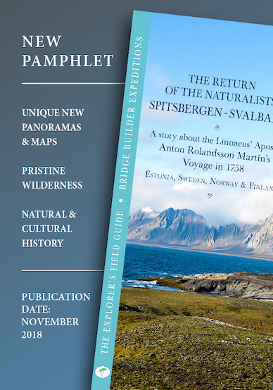
- Hagström, Jonas (accepted 2018). ‘Where Swedish polar research began – the Linnaean apostle Anton Rolandson Martin’s voyage to Spitsbergen in 1758’. Polar Record.
- Hansen, Lars, ed. The Linnaeus Apostles Global Science & Adventure, 8 Volumes, London & Whitby 2007-2012.
- Hansen, Viveka, Textilia Linnaeana – Global 18th-century Textile Traditions & Trade, London 2017.
- Jackson, C. Ian, ed. The Arctic Whaling journals of William Scoresby the younger, Vol. III, The voyages of 1817, 1818 and 1820, Hakluyt Society, London 2009.
- Mills, William James, Exploring Polar Frontiers – A Historical Encyclopaedia, Volume One & Two, Santa Barbara 2003.
- Mehlum, Fridtjof, ‘Anton Martin – den første svensken på Svalbard’, Polarboken 2013-2014, Oslo 2014, pp. 68-74.
- Munsterhjelm, Ludvig, En sommar i Norra Ishavet, Stockholm 1911.
- Norwegian Polar Institute, The Place Names of Svalbard, Rapportserie nr. 122, Tromsø 2003.
- Rolandsson Martin, Anton, ‘Meteorologiska Observationer, gjorde på en Resa til Spits-Bärgen’. Kungliga Vetenskaps Academiens Handlingar (KVAH) vol XVIII-XL 1757-1779, 1758.
- Rolandsson Martin, Anton, ‘Beskrifning på en procellaria, som finnes vid Norr-polen.’ Kungliga Vetenskaps Academiens Handlingar (KVAH) vol XVIII-XL 1757-1779, 1758.
- Rolandsson Martin, Anton, ’Dagbok hållen vid en resa till Norrpolen eller Spitsbergen, på Kongl. Vetenskapsakademiens omkostnad och med ett Grönländska compagniet i Göteborg tillhörande skepp är 1758 förrättad.’, Ymer tidskrift, published by Svenska sällskapet för antropologi och geografi 1881, Stockholm 1882.
- Sysselmannen på Svalbard, Forvaltningsplan for Nordvest-Spitsbergen, Forlandet og Sør-Spitsbergen nasjonalparker, samt fuglereservater på Svalbard, 2017 – 2024. Rapportserie Nr. 2/2017.
- Woeste, H. Mastering Digital Panoramic Photography, Santa Barbara 2009. White, Adam, Ed., A Collection of Documents on Spitzbergen & Greenland, Hakluyt Society, London 1855.
SPECIFICATION OF TECHNICAL EQUIPMENT REQUIRED
- Digital HD camera system with a medium-format sensor connected to NAS
- FLIR Thermal Camera A300
- AXIS Q1765-LE PT Mount Network Camera
PARTICIPATING ORGANISATIONS
The IK Foundation, United Kingdom & EU
WEBSITE
www.ikfoundation.org
PROJECT MANAGER
Lars Hansen, The IK Foundation, United Kingdom & EU. (International correspondence address) The IK Foundation, Franz-Joseph-Str. 11, 80801 Munich, Germany.
FIELD
STATION
NATURAE OBSERVATIO
The IK Foundation has taken the initiative to develop the next generation of scientific Field Stations. The work with FIELD STATION | NATURAE OBSERVATIO is a long-term project, a practical and theoretical enterprise - and part of the BRIDGE BUILDER EXPEDITIONS - aiming to establish eco-designed autonomous Field Stations, which unattended during night and day, all year-round will observe a selected landscape and its life.
The observations - as well as the designs and structures of stations vary – but is always an interdisciplinary resource to document nature and the environment during a predetermined period of time between one to three years.
For regular updates, we recommend fellowship by subscribing to our monthly newsletter iMESSENGER.
PATRONAGE
This site/project
has been made globally available in collaboration with:
 Feel welcome to read more about how to take part...
LINKS | FURTHER READING
- BRIDGE BUILDER EXPEDITIONS SPITSBERGEN
- Research in Svalbard (RIS)
- RIS-ID 10275 (Bridge Builder Expeditions Spitsbergen)
- RIS-ID 11055 (Field Station Research Projects)
- The Norwegian Polar Institute's topographical Svalbard map portal


PROJECT GOVERNING
Lars Hansen | The IK FoundationArne Ardeberg | The IK Foundation
PRINCIPAL REFERENCES & RESOURCES
• The IK Foundation Mission Control Centre | Lars Hansen, Jeff Snoxell, Graham Scott • The Governor of Svalbard | Paul Lutnæs, Morten Wedege • LMK-stiftelsen | Foundation for Interdisciplinary Scientific Research | Malin Ferhm • Research & Reception Desk Office at The IK Foundation | Arne Ardeberg, Jennie Asher, Viveka Hansen, Leo RyderSee also LIST OF PARTICIPATORS
Updated/Checked 09/02/2023
THE IK FOUNDATION & COMPANY PROMOTING NATURAL & CULTURAL HISTORY
FIND OUT MORE @


SUBSCRIBE TO OUR NEWSLETTER
TRANSLATE PAGE

A link to this page has
been copied to your clipboard
SHARE @been copied to your clipboard


© The IK Foundation & Company 2025
– a truly European organisation since 1988
– a truly European organisation since 1988
Legal issues | Forget me | and much more...
Home > Field Station | Naturae Observatio > Photographic Monitoring
