
ikfoundation.org
The IK Foundation
Promoting Natural & Cultural History
Since 1988
- WELCOME
- THE IK WORKSHOP SOCIETY
- THE FIELD STATION LAB
- THE DONATION ROOM
- BOOKS & ART0


- CONTACT
iFellows Sign In
Find out more about becoming an iFellow...My Basket
Items: 0Total: €0.00
The IK Foundation prioritises high-quality book production, ensuring excellence in content and design. Our durable books serve as valuable reference materials, maintaining a tradition we intend to uphold.
In contrast, iBooks offer unique benefits: they can be accessed in the original text and across nearly a hundred translated languages, providing a portable library experience as long as there is internet access.
We view iBooks as valuable research tools and sources of inspiration. Printed volumes are available for purchase in BOOKS & ART and are included in major libraries worldwide.
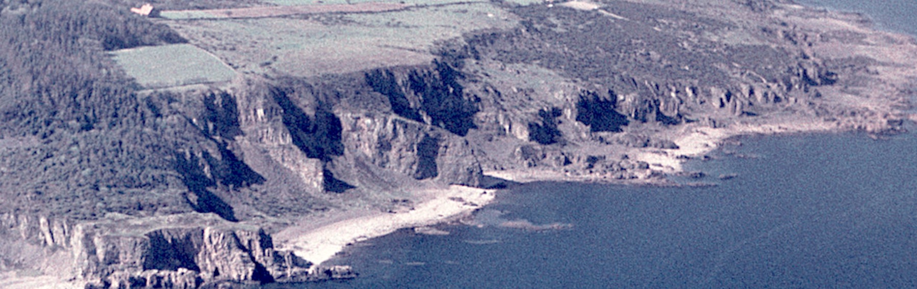
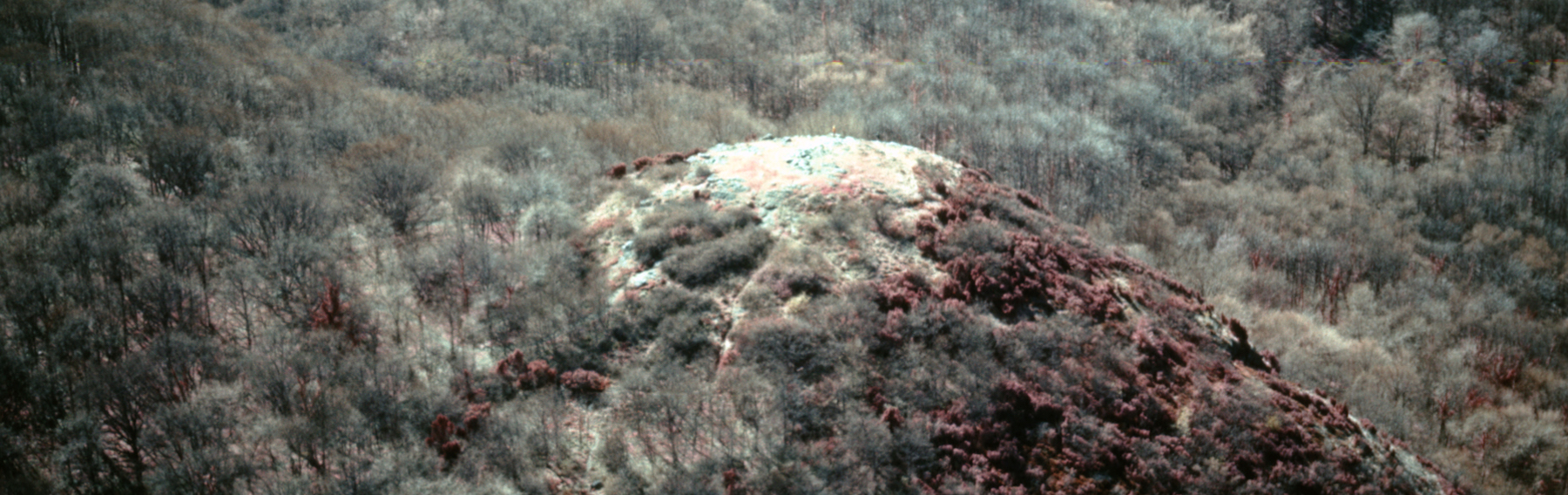
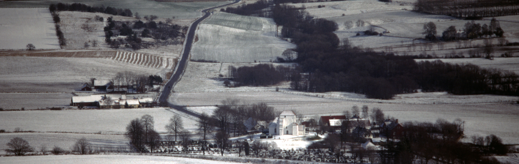
This volume – LOOKING AT HISTORY FROM THE AIR [Flygspaning efter Historia] – features contributions from Scandinavian researchers specialising in aerial photography. Each chapter is based on the work of Esse Ericsson (1921-1996), an unconventional air force major and archaeologist who introduced systematic aerial photography to Scandinavia in the 1950s and 1960s. During this time, he documented the southern Swedish landscape's cultural and topographical aspects. A significant portion of the book, published in Swedish by The IK Foundation in 1992, contains an illustrated, topographically arranged catalogue of Ericsson’s photographs, depicting thousands of objects related to culture, nature, and the environment.
The book opens with a historical perspective of this multidisciplinary branch of archaeology, presented through the late Dr. Gad Rausing’s research on how aerial photographs reveal knowledge about a geographical area over time. He emphasised the unique potential of aerial photographs as additional tools to traditional excavations, providing a broader view of cultural landscapes and detailing aspects otherwise invisible to the human eye. His chapter starts with a photograph from a hot air balloon taken on April 7, 1894, and concludes with a description of a digital database. Gad Rausing published several books from the 1950s to the 1980s, including Arkeologien som naturvetenskap [Archaeology as natural science], which is regarded as a pioneering work in this field.
![LOOKING AT HISTORY FROM THE AIR [Flygspaning efter Historia]](images/iBookiBirdsEyeCollage.jpg)
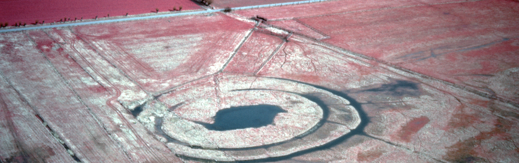
This chapter summarises Esse Ericsson’s 1968 article ‘Plant ecological phenomena and their use for localisation of archaeological and historical objects via looking from the air and aerial photographs’. Ericsson conducted in-depth studies on various nutritious substances and their effects in tracing crop marks via aerial photos. He emphasised factors influencing plant visibility from a fixed altitude, including bedrock, soil, vegetation, bogs, cultivation, land elevation, and drainage. Other considerations for interpreting aerial photographs include topography, climate, waterways, geology, hydrology, and previous roads or grazing cattle.
Jan Norrman from the Swedish National Heritage Board discussed aerial archaeology from the air until the early 1990s in Sweden. He noted challenges that expansive forests hinder picture interpretation, highlighting achievements in Swedish aerial photography, particularly Esse Ericsson’s impactful work in the southern region. Norrman stressed the importance of frequent flying hours to cover areas comprehensively, asserting that Swedish aerial archaeologists had insufficient flight time compared to British teams. In 1983, the Swedish National Heritage Board finally allocated funds for aerial photography of historical monuments, traces of grazing cattle, crop marks, stone circles, ruins, and other significant features.
Chapter four is a brief biography of Esaias (Esse) Ericsson, authored by archaeologist P.U. Hörberg, who first met him during the 1960s at one of his inspiring talks on aerial photography. Born in 1921 in Robertsfors, northern Sweden, Esse became a flying cadet in 1942 in Ljungbyhed, where he began aerial photography during his military career in the 1940s. He maintained and expanded his unique photographic collection over the years. After retiring from the Air Force in 1971, he pursued full-time academic studies in Nordic archaeology, ethnography, and natural geography. He aimed to further his studies using his extensive photographic research for a PhD in Nordic and comparable archaeology, but the institution at Lund University deemed the material insufficient – primarily due to the then institutional management's lack of knowledge and interest in employing modern technology in the subject area, which was completely at odds with international trends. Until the late 1980s, Esse remained active in aerial photography and giving talks, receiving two Royal medals for his work in 1991-1992.
Esse Ericsson's aerial picture collection is one of the world's premier archives focused on a specific geographical area, namely Skåne in southern Sweden, with additional photographs from other regions. Lars Hansen, a naturalist, discusses the archive's historical importance in introducing the catalogue. Donated to IK in 1988, this archive comprises thousands of aerial pictures captured between 1953 and 1972, along with maps, notes, correspondence, literature, and educational resources stemming from Esse's long career. An extensive project, undertaken in three phases from 1988 to 1992, was executed to provide public access to the archive.
The project involved sorting and documenting the archive's status, cleaning and reframing diapositives, and performing other necessary conservation tasks.
Subsequently, the editorial team, including P.U. Hörberg and Lars Hansen, identified the precise geographical origin of each photograph, relying on economic and topographical maps. Consequently, only a small fraction of the thousands of images remain without a known location.
The final steps included completing a detailed catalogue, creating an archival system for long-term preservation, and publishing this book to ensure the unique aerial photographic collection remains accessible for the future.
In contrast, iBooks offer unique benefits: they can be accessed in the original text and across nearly a hundred translated languages, providing a portable library experience as long as there is internet access.
We view iBooks as valuable research tools and sources of inspiration. Printed volumes are available for purchase in BOOKS & ART and are included in major libraries worldwide.
Resumé | Aerial photography aims and methods
This volume – LOOKING AT HISTORY FROM THE AIR [Flygspaning efter Historia] – features contributions from Scandinavian researchers specialising in aerial photography. Each chapter is based on the work of Esse Ericsson (1921-1996), an unconventional air force major and archaeologist who introduced systematic aerial photography to Scandinavia in the 1950s and 1960s. During this time, he documented the southern Swedish landscape's cultural and topographical aspects. A significant portion of the book, published in Swedish by The IK Foundation in 1992, contains an illustrated, topographically arranged catalogue of Ericsson’s photographs, depicting thousands of objects related to culture, nature, and the environment.
Archaeology from the air
The book opens with a historical perspective of this multidisciplinary branch of archaeology, presented through the late Dr. Gad Rausing’s research on how aerial photographs reveal knowledge about a geographical area over time. He emphasised the unique potential of aerial photographs as additional tools to traditional excavations, providing a broader view of cultural landscapes and detailing aspects otherwise invisible to the human eye. His chapter starts with a photograph from a hot air balloon taken on April 7, 1894, and concludes with a description of a digital database. Gad Rausing published several books from the 1950s to the 1980s, including Arkeologien som naturvetenskap [Archaeology as natural science], which is regarded as a pioneering work in this field.
LOOKING AT HISTORY FROM THE AIR [Flygspaning efter Historia]
Archaeology and aerial photography
This chapter summarises Esse Ericsson’s 1968 article ‘Plant ecological phenomena and their use for localisation of archaeological and historical objects via looking from the air and aerial photographs’. Ericsson conducted in-depth studies on various nutritious substances and their effects in tracing crop marks via aerial photos. He emphasised factors influencing plant visibility from a fixed altitude, including bedrock, soil, vegetation, bogs, cultivation, land elevation, and drainage. Other considerations for interpreting aerial photographs include topography, climate, waterways, geology, hydrology, and previous roads or grazing cattle.
Who is flying nowadays for the prehistoric age?
Jan Norrman from the Swedish National Heritage Board discussed aerial archaeology from the air until the early 1990s in Sweden. He noted challenges that expansive forests hinder picture interpretation, highlighting achievements in Swedish aerial photography, particularly Esse Ericsson’s impactful work in the southern region. Norrman stressed the importance of frequent flying hours to cover areas comprehensively, asserting that Swedish aerial archaeologists had insufficient flight time compared to British teams. In 1983, the Swedish National Heritage Board finally allocated funds for aerial photography of historical monuments, traces of grazing cattle, crop marks, stone circles, ruins, and other significant features.
Biographical notes
Chapter four is a brief biography of Esaias (Esse) Ericsson, authored by archaeologist P.U. Hörberg, who first met him during the 1960s at one of his inspiring talks on aerial photography. Born in 1921 in Robertsfors, northern Sweden, Esse became a flying cadet in 1942 in Ljungbyhed, where he began aerial photography during his military career in the 1940s. He maintained and expanded his unique photographic collection over the years. After retiring from the Air Force in 1971, he pursued full-time academic studies in Nordic archaeology, ethnography, and natural geography. He aimed to further his studies using his extensive photographic research for a PhD in Nordic and comparable archaeology, but the institution at Lund University deemed the material insufficient – primarily due to the then institutional management's lack of knowledge and interest in employing modern technology in the subject area, which was completely at odds with international trends. Until the late 1980s, Esse remained active in aerial photography and giving talks, receiving two Royal medals for his work in 1991-1992.
Esse Ericsson’s aerial picture series
Esse Ericsson's aerial picture collection is one of the world's premier archives focused on a specific geographical area, namely Skåne in southern Sweden, with additional photographs from other regions. Lars Hansen, a naturalist, discusses the archive's historical importance in introducing the catalogue. Donated to IK in 1988, this archive comprises thousands of aerial pictures captured between 1953 and 1972, along with maps, notes, correspondence, literature, and educational resources stemming from Esse's long career. An extensive project, undertaken in three phases from 1988 to 1992, was executed to provide public access to the archive.
The project involved sorting and documenting the archive's status, cleaning and reframing diapositives, and performing other necessary conservation tasks.
Subsequently, the editorial team, including P.U. Hörberg and Lars Hansen, identified the precise geographical origin of each photograph, relying on economic and topographical maps. Consequently, only a small fraction of the thousands of images remain without a known location.
The final steps included completing a detailed catalogue, creating an archival system for long-term preservation, and publishing this book to ensure the unique aerial photographic collection remains accessible for the future.
PATRONAGE
This site/project has been made globally available in collaboration with:
 The Thora Ohlsson Foundation, Lund, Sweden
Feel welcome to read more about how to take part...
The Thora Ohlsson Foundation, Lund, Sweden
Feel welcome to read more about how to take part...
AVAILABLE iBOOKS
The IK Foundation & Company Promoting Natural & Cultural History
|
Subscribe to our Newsletter | IK Global iMessenger |
Translate Page |
|
|
© The IK Foundation & Company 2025 - a truly European organisation since 1988 |
Research &
Enterprise
Enterprise
The IK
Workshop Society
Workshop Society
The Field
Station Lab
Station Lab
How to cite & Creative Commons
You are welcome to use the information and knowledge from
The IK Workshop Society, as long as you follow a few simple rules.
LEARN MORE & I AGREE
You are welcome to use the information and knowledge from
The IK Workshop Society, as long as you follow a few simple rules.
LEARN MORE & I AGREE
